Getting lost during a trail race: what to do when course markings disappear
Getting lost during a trail race: it happens more than you think
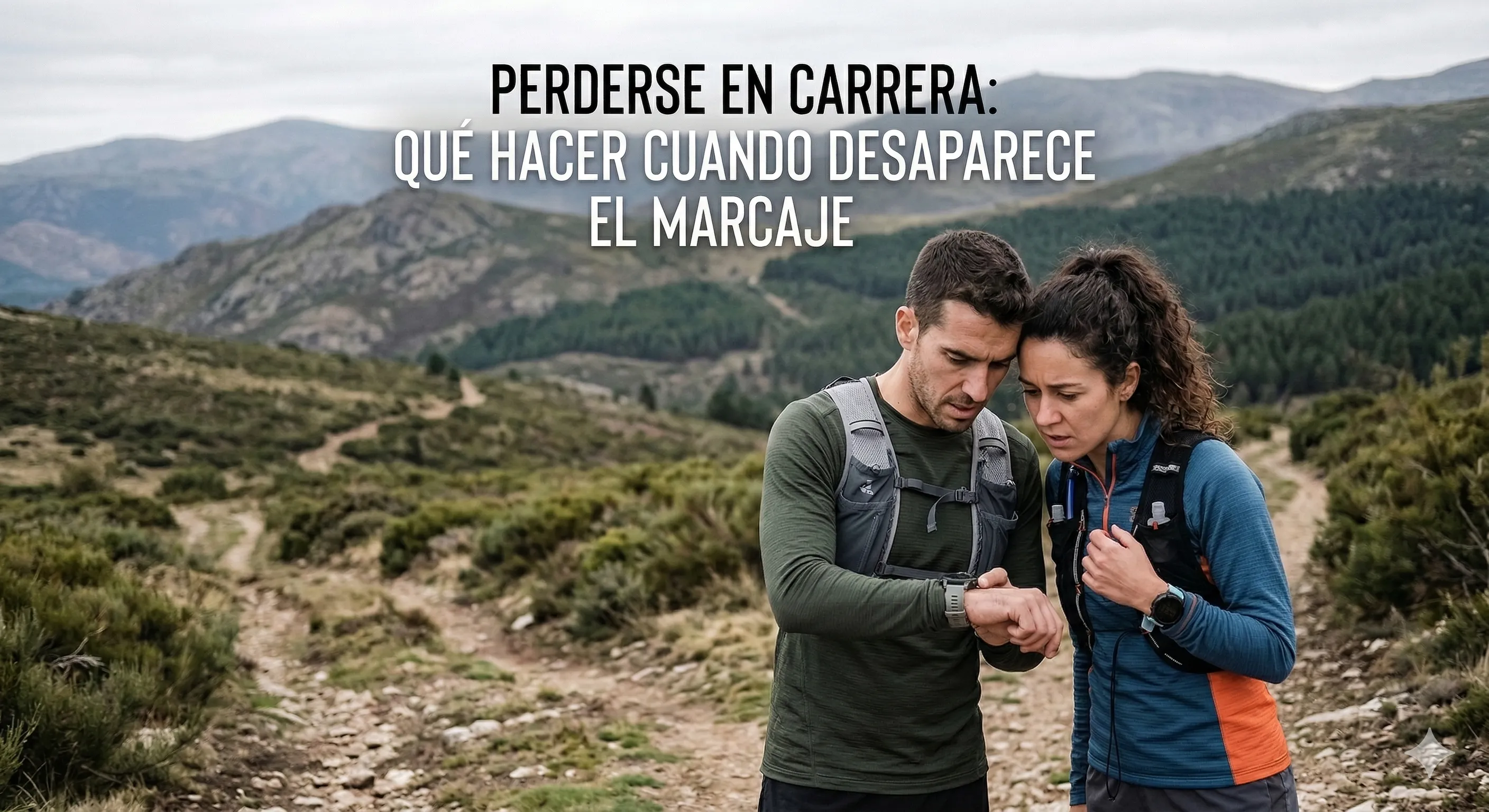
You’re at km 28, you’ve been climbing for two hours, the group has spread out and suddenly… you can’t see the next marker. No tape, no flag, no runner ahead. Just mountain. That “which way was it?” moment has happened to almost everyone who runs in the mountains, from first-timers to experienced runners.
A study by the ITRA (International Trail Running Association) indicates that between 5% and 15% of participants in mountain races go off course at least once during the event. In unsupported training runs with no course markings, the percentage is much higher.
The good news: getting lost doesn’t have to become an emergency. With some preparation and the right tools, you can correct your course in minutes. This guide covers everything: from prevention to a step-by-step protocol when you find yourself off course.
Why we get lost: the most common causes
Before looking at what to do, it helps to understand why it happens. That way you can prevent it:
During a race
- Insufficient or missing markings: tape blown away by wind, flags removed by someone, paint washed off by rain. It’s not rare, especially in long-distance races where organizers cover many kilometres.
- Following the runner ahead: you trust that the runner 50 metres in front knows where they’re going. But if they take a wrong turn, everyone follows.
- Unmarked junctions: the critical point. A trail junction missing a single piece of tape is the number one cause of mass wrong turns.
- Night and fog: with a headlamp you lose perspective, and in fog markers are visible at half their usual distance. Risk multiplies above 2,000 m.
- Mental fatigue: after 8-10 hours of running, attention drops. You take a wrong trail without even noticing.
During training
- Not downloading the track: you head out “from memory” on a route you think you know, but get confused at a junction.
- Not studying the course: you have the track on your watch but haven’t looked at the map beforehand. You can’t interpret what you see on the screen.
- Terrain changes: a fallen tree, a new forest road, modified trail signage. The mountain changes.
Prevention: what you do BEFORE you leave matters most
1. Always download the GPX track
Whether it’s a race with 5,000 markers or a training run on your usual trails, download the GPX track to your watch or phone. It’s your insurance against any course-marking failure.
- For races: the organization publishes the official track on their website. Download it days in advance and load it on your GPS watch.
- For training: create the track on Wikiloc, Strava or Komoot and export it as GPX. Also download the offline map of the area.
2. Study the course beforehand
Having the track on your watch isn’t enough. Spend 10 minutes studying it on a map:
- Identify key junctions: the crossroads where getting lost is most likely.
- Memorise visual references: “after the fountain, turn right”; “past the firebreak, trail on the left”.
- Note the points of no return: if you pass this point and haven’t seen X, you’re off course.
- Check the elevation profile: if you’re climbing when the track says you should be descending, something’s wrong.
3. Carry a GPS watch with navigation
A GPS watch with track-following capability is the most reliable tool for staying on course. Unlike your phone, it won’t die after 4 hours, works in the rain, and is always visible on your wrist.
The Coros Pace 3 is one of the best value options for runners who are starting out or looking for a reliable watch without breaking the bank:
- 38 hours of battery life in GPS mode: enough for any ultra.
- GPX track navigation: load the course and follow the line on screen.
- Off-course alerts: if you stray from the track, it vibrates to warn you.
- 39 grams: you won’t even notice it on your wrist.
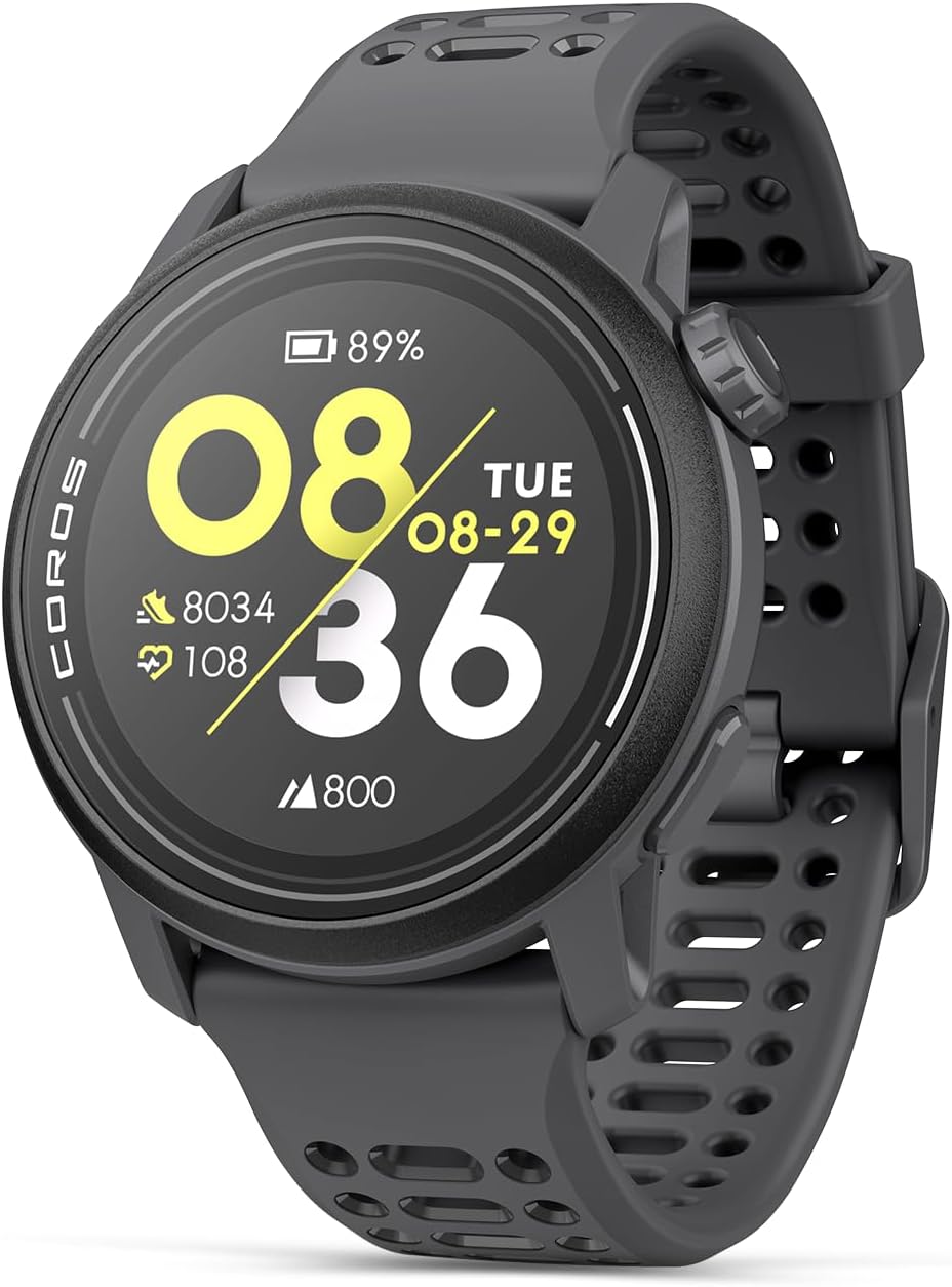
You don’t need the most expensive watch on the market. What you need is a watch that loads GPX tracks and alerts you if you stray. The Coros Pace 3 does that perfectly.
4. Your phone as a backup GPS
The watch is your first line, but the phone is your backup. Prepare it before heading out:
- Download the offline map of the area (Google Maps, Organic Maps or the Wikiloc app itself).
- Load the GPX track in a navigation app (Wikiloc, Organic Maps, Komoot).
- Put the phone in airplane mode during the race to save battery. GPS works without an internet connection.
- Keep it accessible: a running belt with a phone compartment lets you check the map without stopping or opening your pack.
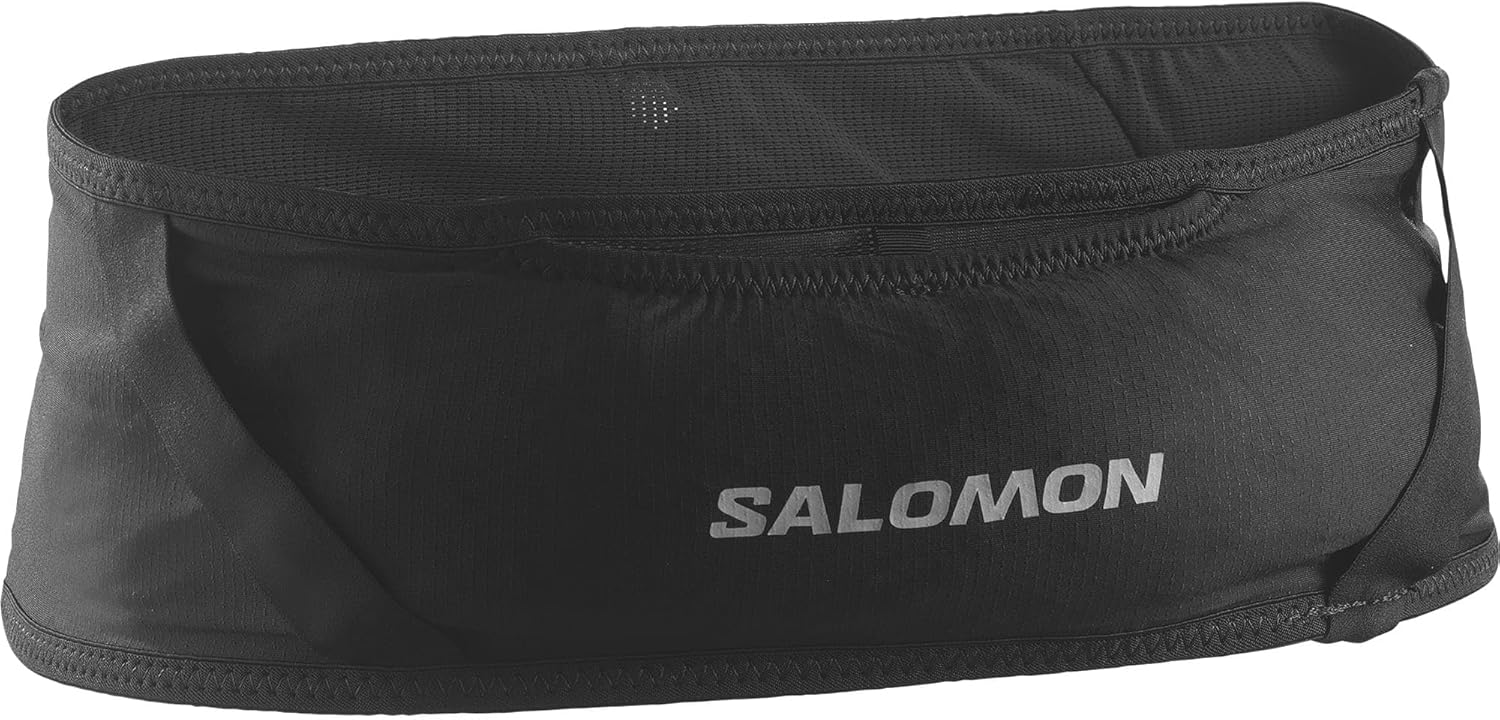
With your phone in an accessible belt, checking the track takes 5 seconds. Without one, digging it out from the bottom of your pack on a climb is a hassle most runners avoid… until it’s too late.
5. Don’t skip the technical briefing
Many runners put in earbuds or chat with friends during the pre-race briefing. Mistake. During the briefing, organizers typically warn about:
- Sections with weak markings or problematic zones.
- Last-minute course changes.
- Points where multiple distances converge and you need to pay attention.
5 minutes of attention at the briefing can save you 30 minutes lost on the mountain.
You’re lost: what to do step by step
OK, despite all the prevention, you’re off course. Don’t panic. Here’s what to do, in order:
Step 1: stop immediately
The most common mistake is continuing forward hoping to find the way. Every metre you advance in the wrong direction is a metre you’ll have to retrace. Stop. Now.
Step 2: check your GPS watch or phone
If you have the track loaded, the answer is on your wrist:
- Where are you relative to the track? The screen will show your position and the course line.
- How far have you strayed? If it’s 50-100 metres, you probably just need to backtrack to the last junction.
- Which direction does the track go? Identify the general direction and orient yourself.
If you don’t have a track loaded, open your phone: Google Maps in satellite mode at least lets you locate yourself and see nearby trails.
Step 3: go back to the last known point
Don’t try to cut cross-country. That’s the fastest way to make things worse. Retrace your steps to the last point where you were sure you were on course:
- The last marker you saw.
- The last junction.
- The last runner who passed you or was with you.
Step 4: look for references
If you can’t retrace your steps (difficult terrain, night, fog), use references:
- Altitude: compare your watch’s altitude reading with the course elevation profile. Should you be higher or lower?
- Direction: is the sun where it should be? Is the valley on your left or right?
- Sound: during a race, you can sometimes hear other runners, an aid station, a river that should be near the course.
- Trail markers: are there GR/PR/SL paint marks on trees or rocks? They can help identify where you are on the map.
Step 5: ask for help if you need it
If you’ve spent more than 15-20 minutes without finding the route and you’re not sure where you are:
- During a race: call the organization’s emergency number (write it on your wrist with a marker before the start, in case your phone fails).
- During training: call someone you trust and give them your exact GPS coordinates (from your phone or watch).
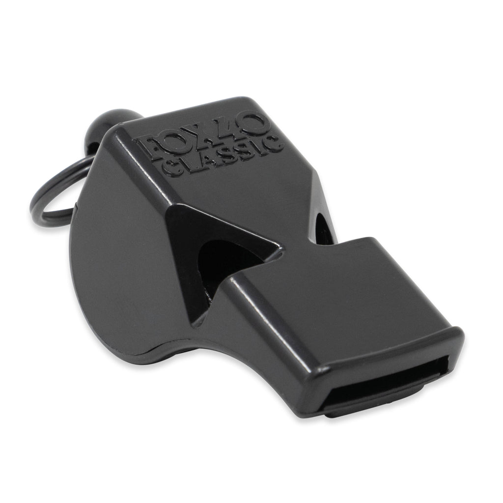
- If there’s no signal: use your whistle (three blasts, pause, three blasts) and return to the last known trail.
Step 6: if it’s getting dark, stop
If you’re lost and night is falling, don’t try to find the way in the dark unless you have a headlamp, a GPS track and experience with night running. It’s better to:
- Find a spot sheltered from the wind.
- Put on all the warm clothing you have.
- Wait for dawn or for help to arrive.
A powerful headlamp (>200 lumens) doesn’t just help you walk: it’s a signal visible for kilometres to rescue teams or nearby runners.
Navigation apps: which to use and how
Wikiloc
The most popular in Spain for trail running. Lets you download GPX tracks from other users, create your own and follow them on your phone. Download the offline map before heading out — without it, the app won’t work without signal.
Organic Maps
Free, ad-free alternative. Uses OpenStreetMap data, which in rural and mountain areas often has better detail than Google Maps. Supports GPX track import. Works 100% offline.
Komoot
Good for planning routes with information about terrain type and difficulty. Its navigation mode with voice instructions is useful, though it drains more battery than the alternatives.
Google Maps offline
Not suitable for following tracks, but useful for locating yourself in a pinch. Download the area before heading out: menu → Offline maps → Select area.
Tip: always carry two navigation options. GPS watch + phone with track loaded. If one fails, you have the other.
Navigation kit: what to carry so you don’t get lost
| Item | Weight | What it’s for | Essential? |
|---|---|---|---|
| GPS watch with tracks | 39-50 g | Primary navigation, off-course alerts | Yes |
| Phone with offline map | - | Backup GPS, communication, alternative track | Yes |
| Running belt with phone pocket | 80 g | Quick map check without stopping or opening pack | Highly recommended |
| Whistle | 10 g | Signalling if lost without phone signal | Yes |
| Headlamp | 75 g | Night navigation, visual signalling | If there’s any risk of darkness |
Total navigation kit weight: under 200 g (not counting the phone you’re already carrying). That’s what it weighs to be prepared for never getting lost.
7 mistakes runners make when they get lost
-
Pressing on “in case the markers reappear”. Every wrong step takes you further from the route. Stop and assess.
-
Not loading the track because “the race is well marked”. Even the best-organized races have weak points in their marking. Always load the track.
-
Blindly following the runner ahead. Especially at night or in a group. Everyone should know where they’re going.
-
Panicking and running cross-country. Breathe, check your watch, return to the last safe point. Never shortcut across unknown terrain.
-
Not writing down the race organization’s emergency number. It won’t be on your phone when you need it most. Write it on your wrist or bib.
-
Heading out without an offline map on your phone. GPS works without internet, but the map won’t load on its own. Download it beforehand.
-
Ignoring the technical briefing. Organizers warn about problematic sections. 5 minutes of attention is worth more than 30 minutes lost.
Checklist before every race or long run
- ✅ GPX track downloaded on GPS watch
- ✅ GPX track also loaded on phone (backup)
- ✅ Offline map downloaded (Wikiloc, Organic Maps or Google Maps)
- ✅ Course studied: key junctions and visual references
- ✅ Phone charged to 100%, airplane mode during the race
- ✅ Running belt or accessible phone holder
- ✅ Whistle accessible
- ✅ Headlamp if there’s any chance of darkness
- ✅ Race organization emergency phone number written down
Getting lost isn’t the problem; being unprepared is
99% of wrong turns during a race are resolved in under 5 minutes if you carry a GPS watch with the track loaded. The other 1% are resolved with calm, a phone with a map and a cool head.
The total investment to never get lost again: a GPS watch (€230) that you’ll use on every run for 5 years, a running belt (€25) and 10 minutes of preparation before each race. Compare that to the 45 minutes you lost the last time you took the wrong fork.
If you want to go deeper on mountain safety gear, check our complete mandatory gear guide for ultra trail. And if a situation ever goes from “I’m lost” to “I’ve fallen and can’t move”, we’ve got you covered with what to do when you fall on the trail.